 "daender" (daender)
08/06/2014 at 15:12 • Filed to: None
 3
3
 21
21|
"daender" (daender)
08/06/2014 at 15:12 • Filed to: None | 3
| 21 |
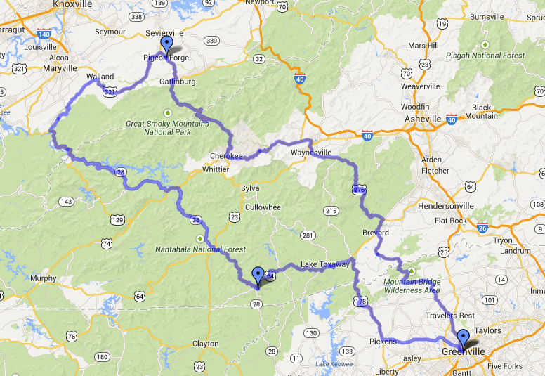
Mountain Run 2014 is a go, repeat, !!!error: Indecipherable SUB-paragraph formatting!!! is a go. The current plan is to meet up in G-Ville/Travler's Rest Oct 23rd and spend 2-3 days driving through the mountains in the daytime and camping out during the nights. I think we should get Torchbuggy by then at take it along for a ride. To other oppos, if you're in the local area long the current estimated route, then feel free to say hi to the derp driving the silver NB Miata.
 Desu-San-Desu
> daender
Desu-San-Desu
> daender
08/06/2014 at 16:54 |
|
Awesome! Finances permitting, I should be good to go.
|
Desu-San-Desu
> daender
08/06/2014 at 17:24 |
|
Can you maybe link me the Google Map with the route programmed into. I want to look at the topography.
 mattoverdrive
> daender
mattoverdrive
> daender
08/06/2014 at 17:27 |
|
Why not just do it in one day. :)
|
daender
> Desu-San-Desu
08/06/2014 at 18:58 |
|
https://maps.google.com/maps/ms?msid=2…
Yup, here you go!
|
daender
> mattoverdrive
08/06/2014 at 18:59 |
|
It's quite of a long drive, last year's trip was less than half that distance and it took a whole day including breaks for ourselves and our cars.
|
Desu-San-Desu
> daender
08/06/2014 at 19:02 |
|
Awesome! Might I recommend an adjustment to the beginning of the route?
|
daender
> Desu-San-Desu
08/06/2014 at 19:08 |
|
Sure, shoot ahead, though I recommend voicing it on the facebook page so anyone else can see chime in if necessary.
|
Desu-San-Desu
> daender
08/06/2014 at 19:16 |
|
It's small. Instead of jumping straight onto 183, which generally has a low speed limit and more traffic than one would think, I would recommend taking 123 into Easley, where everyone can grab a bite to eat, and then taking Grant Valley and N. Old Mill (My old FR-S test route that I showed you) up to 183. This will skip at least half of 183, allow people to stock up, and give them a quick taste of the local roads so they can know what to expect before we pass through Pickens.
|
Desu-San-Desu
> daender
08/06/2014 at 19:20 |
|
Oh...wait, apparently I was reading it wrong. We're going counterclockwise, aren't we? If so, then NEVERMIND! XD
|
daender
> Desu-San-Desu
08/06/2014 at 19:28 |
|
Yup, that's the plan!
|
Desu-San-Desu
> daender
08/06/2014 at 19:32 |
|
Oh...well then, I still say we end in Easley at the Wal-Mart like last time. XD
|
daender
> Desu-San-Desu
08/06/2014 at 19:32 |
|
Haha, that's probably going to happen again, and you can lead us down your FR-S-selling route once more.
|
Desu-San-Desu
> daender
08/06/2014 at 19:34 |
|
Want me to adjust the route accordingly when I get back from karting?
|
daender
> Desu-San-Desu
08/06/2014 at 19:49 |
|
Yes please.
|
mattoverdrive
> daender
08/06/2014 at 20:23 |
|
I was just screwing with you. It looks like it'd be a good two day trip, three would be stretching it unless you were planning on driving a couple of roads more than once.
Also, if I could make suggestion avoid Pigeon Forge, you'll spend too much time in traffic. Instead, when you're first come into Gatlinburg you can take Old State Highway 73 Scenic by the Sugarlands visitor center. Its a fun road to drive, and it'll take you through the national park directly to Walland avoiding Pigeon Forge. You may still get stuck behind some tourists, but it'll be nothing like going through Pigeon Forge.
Looks like a rocking trip!
|
Desu-San-Desu
> daender
08/06/2014 at 20:51 |
|
Oh...wait. I don't have edit permissions. XD
|
daender
> Desu-San-Desu
08/06/2014 at 20:55 |
|
Darn, maybe plot it yourself and I'll edit in your linked version?
|
Desu-San-Desu
> daender
08/06/2014 at 21:04 |
|
Here ya go: http://bit.ly/1siru0s
Leads from Pickens to 85, which will take you to 185 back to Columbia.
|
daender
> Desu-San-Desu
08/06/2014 at 21:49 |
|
Perfect, I added it into the newest version (v2) of DA PLAN.
|
Desu-San-Desu
> daender
08/06/2014 at 22:05 |
|
I see that. I made some notes, just because I'm an annoying little shit like that. :-P
I wonder if there's a way to make it editable by a select group of people?
|
daender
> Desu-San-Desu
08/06/2014 at 22:15 |
|
I have no idea, I'm still getting used to using google maps in a public manner. IT took me a good 10-15 minutes to replicate the original route proposed by Kyle and another 5-10 to plug in yours. Granted, I'm distracted by a lot of things at home right now.